Dr. Will on how to find fossils
What does a paleontologist need to know to go out and find fossils?
You probably know that dinosaurs lived during the Mesozoic, a period of time that started on the first day of the Triassic about 225 million years ago and ended with last day of the Cretaceous about 65 million years ago. If you search for fossils in rocks that are older than the Triassic—in rocks from the Permian, which might be 280 million years old—you might find fossil fish or bones from the pelycosaurs we discussed last time, but you won't find dinosaurs because the rocks aren't the right age. Rocks younger than 65 million years old might contain fossil horses, but again no dinosaurs. In order to find dinosaur fossils, you need to know the age of the rocks you're hunting in.
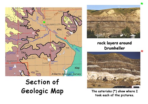
Paleontologists use a special type of map called a Geologic Map that shows roads and cities (like other maps) but also the age of surface rock. Picture #1 (above) includes a section of a geologic map of Alberta, made by the Alberta Geologic Survey; on this map, you can see several swirls of color, each with bold labels: "Khc", "Kbp", and "Ks" are examples. In each case, the "K" means Cretaceous—so the rocks around Drumheller, the city closest to the Tyrrell Museum, are the right age to contain dinosaurs. However, even though a rock is the right age, it may still not be the right kind of rock to contain dinosaurs.
Rocks come in three general types, and only one type preserves fossils. Igneous rocks are melted deep inside the earth and sometimes erupt through volcanoes but are too hot to preserve fossils. Metamorphic rocks are very old rocks that have been deeply buried; they get squeezed and cooked and changed, but they're too far down to collect bones. Sedimentary rocks, which are made from sand and mud stirred at the surface by wind and water, can capture and keep old bones. These rocks come in layers, almost like a stack of pancakes. When sliced open by a river, the stack of layers is exposed, as shown in the photos in Picture #1 (above). The geologic map will show you where you can find sedimentary rocks.
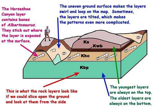
Each layer of sedimentary rocks, usually called a formation, has a special name, also shown by the geologic map. You might have already guessed that the "hc" part of "Khc" stands for the "Horseshoe Canyon" Formation. "Kbp" represents the Bearpaw Formation, and "Ks" represents the Scollard Formation. Each layer is a bit different—there are lots of different kinds of sedimentary rocks too! On the map, the colors don't seem to make a stack, but that's because the hills and valleys are eroded and lumpy, as shown by Picture #2 below.
posted by dino kids @ 6:31 PM
![]()
![]()

<< Home